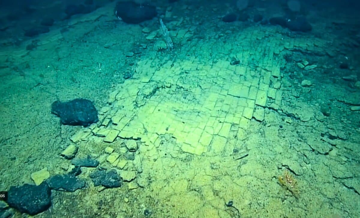
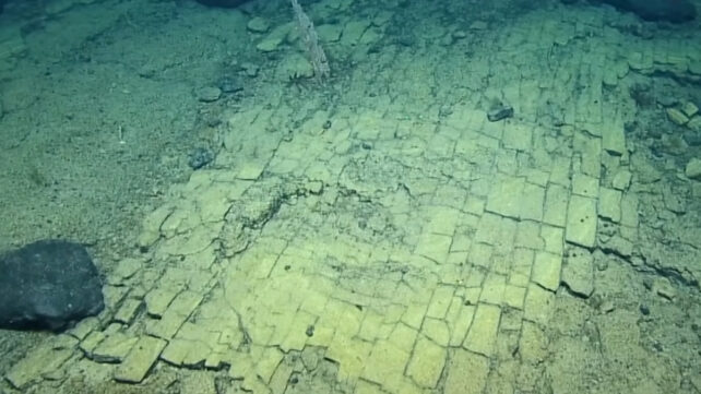
Researchers aboard the exploration vessel Nautilus filmed a dried lakebed formation paved with fractured volcanic rock at a depth of 3,000 meters on the Liliʻuokalani Ridge, within the Papahānaumokuākea Marine National Monument.
The 20-second video segment, shows remotely operated vehicle footage of what scientists immediately described as a “yellow brick road” during the live dive. The formation covers part of the summit of Nootka Seamount, an underwater volcano in an expansion area of the monument designated by President Barack Obama in 2016. The monument now encompasses 582,578 square miles of the Pacific Ocean, an area larger than all US national parks combined.
According to the expedition log, the formation is a fractured flow of hyaloclastite rock, a volcanic material created in high-energy eruptions where fragmented rock settles to the seabed. The 90-degree fractures visible in the video are likely related to heating and cooling stress from multiple eruptions at what geologists term a baked margin.
A ‘Yellow Brick Road’ at 3,000-Meter Depth
The discovery occurred during the Luʻuaeaahikiikekumu expedition, the first visual survey of the Liliʻuokalani Seamounts following a 2021 mapping mission. That earlier expedition, Luʻuaeaahikiikalipolipo, had mapped the previously uncharted seamount chain using multibeam sonar, revealing summit depths far shallower than expected for Cretaceous-era formations dating between 66 and 145 million years old.
As detailed in the Wikipedia entry for Papahānaumokuākea, only about three percent of the monument’s seafloor has been visually explored. A 2025 study published in Science Advances calculated that across 67 years of deep-sea recording, humans have visually explored between 0.0006 and 0.001 percent of the deep seafloor globally.
The expedition team included cultural liaisons from Native Hawaiian organizations, reflecting what the Ocean Exploration Trust described as the first inclusion of Hawaiian language and practice in its expeditions to the region. The name Luʻuaeaahikiikekumu translates to references in the Kumulipo, the Native Hawaiian origin chant.
A Geologic Explanation for the Brick-Like Pattern
Hyaloclastite formations like the one documented at Nootka Seamount occur when lava encounters water, either during submarine eruptions or when terrestrial lava flows enter the ocean. The resulting fragmentation produces angular rock fragments that cement together. The brick-like pattern results from contraction as the material cools.
“At the summit of Nootka Seamount, the team spotted a ‘dried lake bed’ formation,” the Nautilus Live video description states. “The unique 90-degree fractures are likely related to heating and cooling stress from multiple eruptions at this baked margin.”
During the live dive, researchers on the radio can be heard describing the formation. The full video footage captures their reactions in real time. “It’s the road to Atlantis,” one researcher exclaims. “The yellow brick road?” another responds. A third adds, “This is bizarre.”
The researchers also collected samples of basalt coated with ferromanganese crusts, mineral deposits that accumulate over millions of years, from various depths across the seamount chain. Scientists are analyzing microbial communities living within these crusts to establish baseline data for seamount ecosystem management.
Sampling Limits
The 2022 expedition operated under several limitations. Visual surveys were confined to ROV dive paths, sampling was restricted to accessible rock surfaces, and the age of specific formations remains undetermined pending laboratory analysis of collected samples. The expedition overview for NA138 states that a primary objective is determining the geologic origin and age of these seamounts to better understand the formation of the Northwestern Hawaiian Islands.
The research is funded by NOAA Ocean Exploration through the Ocean Exploration Cooperative Institute, with additional support from the NOAA Office of National Marine Sanctuaries. The monument is jointly managed by the Department of Commerce, Department of the Interior, State of Hawaiʻi, and Office of Hawaiian Affairs.
Analysis of samples collected during the expedition is ongoing at multiple institutions. Results will inform a scheduled 2026 review of management strategies for deep-sea habitats within the monument, according to the cooperative institute’s research timeline.
First Appeared on
Source link


Leave feedback about this