Another significant winter storm is in the forecast — this time for early March, forecasters said.
“Fresh Arctic air will set the stage for a storm early next week that could bring disruptive snow and ice to parts of the Midwest and Northeast,” said AccuWeather meteorologist Alex Sosnowski in an online forecast.
However, “before the bigger storm threat arrives, smaller wintry events will move through the regions,” he said.
Light snow in forecast first
Following a minor event Thursday, Feb. 26, a narrow swath of snow is then forecast to develop Friday, Feb. 27 into Saturday night, Feb. 28 ahead of a surge of Arctic air plunging southeastward from Canada, AccuWeather said.
The snow will begin in Montana Friday, Feb. 27, spread into the Midwest Friday night and reach the interior Northeast Saturday night, Feb. 28. Most areas will pick up a coating to a couple of inches, Sosnowski said.
Chicago, Minneapolis and Detroit may pick up an inch or so from Friday night to Saturday night.
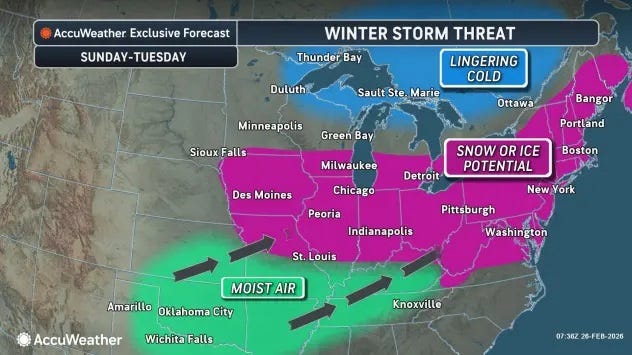
Fresh Arctic air in place
A key ingredient in major winter storms is fresh cold air — and next week’s system will have plenty in place.
With fresh Arctic air in place, warm and moist air colliding with the cold air may produce widespread snow, sleet and freezing rain across parts of the Great Lakes and Northeast.
Not a ‘blockbuster storm’
The National Weather Service said that “while this is not expected to be a blockbuster storm, it does seem probable that plowable snow and some ice will occur. Snow is currently expected across portions of the Mid-Mississippi Valley, Ohio Valley, and Mid-Atlantic.”
“Just to the south, this pattern will also favor a swath of mixed precipitation like sleet and freezing rain. Accumulations and track of the wintry weather remain uncertain, so continue to monitor forecasts,” the weather service said.
Snow and ice totals will depend on the storm’s track and strength, AccuWeather said. “Some areas that missed the recent Blizzard of 2026 could receive several inches of snow and/or some ice this time,” Sosnowski said.
A storm will spread snow and ice across the Midwest and Northeast early next week, forecasters said.
Not a repeat of the blizzard
This storm is highly unlikely to rival the blizzard from February, especially across the coastal Northeast. However, some areas that got little or no snow from that storm in the Northeast or Midwest could pick up several inches of snow and/or some ice, AccuWeather said.
The risk of travel disruptions will increase from Monday, March 2 through Wednesday, March 4, depending on the storm’s exact track and strength. Major airport hubs from Washington, DC, and Philadelphia to New York City, Boston, Detroit and Chicago could be affected.
Where rain falls, most likely in parts of the Ohio Valley and mid-Atlantic states, urban flooding is possible. A farther north track could elevate the risk of ice jams and related stream and river flooding, AccuWeather warned.
This article originally appeared on USA TODAY: Early March forecast warns Northeast of another snowstorm
First Appeared on
Source link


Leave feedback about this