On the high plateau of the Nazca Desert in southern Peru, the ground looks almost empty from eye level. A reddish skin of stones covers pale soil, broken only by low hills and dry gullies. Yet from the air, faint lines and curves emerge where people scraped the surface more than 2,000 years ago. Many are now so eroded that a passing hiker would never guess they exist at all.
For most of the past century, archaeologists tried to map this silent artwork with planes, cameras, and long days on foot. Across about 629 square kilometers of the Nazca Pampa, field surveys slowly identified 430 figurative Nazca Lines, an average of roughly one or two new figures per year. Even high-resolution photos still had to be checked by tired human eyes. Researchers suspected many more Nazca geoglyphs were still buried in plain sight, but a complete inventory looked unreachable.
Between September 2022 and February 2023, that pace changed. A team led by archaeologist Masato Sakai at Yamagata University partnered with data scientists at IBM Research to run an AI-accelerated Nazca survey across the entire plateau. Instead of scanning every image by hand, they asked a computer model to flag the most promising shapes for closer inspection. Only after the software is finished did the archaeologists lace up their boots and return to the desert trails.
How AI Learned to Read the Desert
At the core of the project was an artificial intelligence system built to recognize the visual fingerprints of earthworks rather than buildings or roads. The team used deep learning techniques that first trained on everyday photographs and then were fine-tuned on a few hundred known Nazca figures. That small training set was a challenge, since most image recognition models rely on tens of thousands of examples per class. To stretch the data, the researchers chopped each confirmed figure into many overlapping tiles, turning every geoglyph into a stack of training samples.
Instead of drawing bounding boxes directly on the desert, the model produced a continuous geoglyph probability map with a resolution of five meters. Areas with higher probabilities outlined small patches where a geoglyph might exist. Over the full Nazca Pampa, the system generated 47,410 candidate patches that could contain previously unknown Nazca geoglyphs. Each patch linked back to the precise coordinates where field teams could later stand and check the ground.
Human specialists then took over. Using high-resolution imagery from aircraft and drone surveys based on modern remote sensing techniques, they screened the 47,410 candidates on computer screens and narrowed them to 1,309 high potential sites. Small drones, or UAVs, later flew over those priority locations to capture ultra-detailed photographs of stone patterns and subtle color shifts in the soil. Altogether, experts spent about 1,200 hours on digital screening before anyone set foot back on the plateau.
What the Field Survey Revealed
During six months of walking surveys, the team visited 341 of the most promising spots under permits from the Peruvian authorities. Ground checks required another 1,440 labor hours as archaeologists traced faint outlines, compared them with the imagery, and confirmed which shapes were human made. The result was a catalog of 303 new figurative Nazca geoglyphs, plus 42 additional geometric designs that had never been recorded before. Combined with the earlier figures, the relief style inventory now totals 683 examples across the desert.
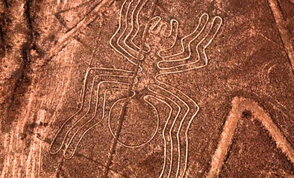
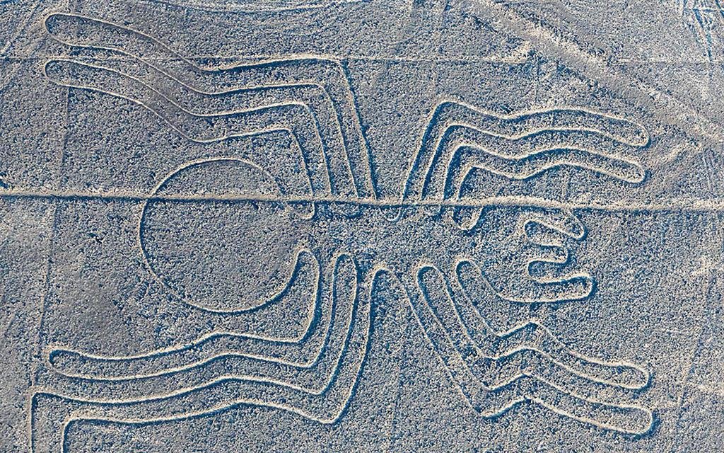
Most of the new finds belong to the category of relief-type geoglyphs, which are made by piling or removing stones to create subtle contrasts. These images are small, averaging about nine meters in length, and are often placed on slopes or low rises where people would see them from nearby trails. By contrast, the giant line-type geoglyphs average about 90 meters and lie on flatter ground, shaped as long straight segments and wide trapezoids that can be followed over great distances.
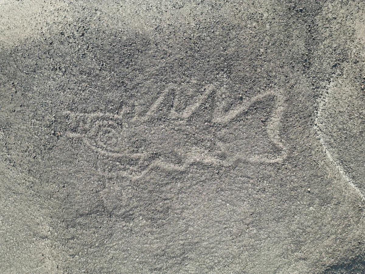
Motifs differ as much as scale. Relief style figures mostly depict humans, decapitated heads, and domesticated camelids such as llamas, forming about 81.6 percent of the sample. Line type designs favor wild animals like birds, whales, and other creatures, which constitute about 64 percent of that smaller group. One newly documented relief style figure shows a 22-meter killer whale holding a knife, a motif that matches scenes painted on Nazca pottery.
The AI guided survey also showed that the two styles occupy different paths through the landscape. Relief style groups sit within an average of 43 meters of informal, winding trails that weave across the plateau. Line type figures lie about 34 meters from straight lines and trapezoids that formed a more formal network between river valleys and ceremonial centers. The pattern supports the idea that many relief scenes were meant for people walking local paths, while the larger figures anchored long distance processions.
How Fast the Nazca Map Is Growing
The study, published in Proceedings of the National Academy of Sciences (PNAS), quantifies how quickly the new workflow speeds up discovery. From the 1940s to the early 2000s, surveys added figurative Nazca geoglyphs at roughly 1.5 per year. With the rise of high-resolution imagery after 2004, that rate climbed to about 18.7 per year as researchers spotted more small figures on photographs. Compressing 303 confirmed figurative geoglyphs into a single 2022–2023 field season means the AI assisted survey achieved roughly a sixteen-fold acceleration beyond even that improved pace.
For Sakai and his colleagues, the key benefit is not that software replaces fieldwork but that it directs it. “The use of AI in research has allowed us to map the distribution of geoglyphs more quickly and accurately,” said archaeologist Masato Sakai of Yamagata University. The model still points to 968 high potential sites that have yet to be checked, and statistical estimates suggest that at least 248 additional AI proposed figures are likely to be genuine.
The project has also become a reference case for AI archaeology and drone-based surveys worldwide. It was documented in detail in the journal Proceedings of the National Academy of Sciences, where the authors describe their geoglyph probability maps, ranking system, and field verification strategy. That technical record turns a local desert campaign into a method other teams can adapt for different kinds of faint archaeological features.
First Appeared on
Source link


Leave feedback about this