Today is day two of severe weather stretching from the South to the Ohio Valley and mid-Atlantic states that already spawned multiple destructive tornadoes, giant hail and damaging winds in the Midwest and Plains Tuesday. This is happening less than a week after an outbreak of 24 tornadoes swarmed over many of the same areas.
Happening Now
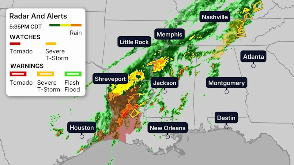
A line of severe thunderstorms is sweeping through the Ohio Valley. Gusts from 60 to 70 mph have downed trees, knocked out power and even lead to some structural damage in parts of Illinois, Indiana and Ohio this morning.
A barn was leveled near Botkins, Ohio, a roof was blown off a building in Richmond, Indiana, and damage to roofs of homes was also reported in Pendleton, Indiana, due to high winds, Wednesday morning.
Scattered severe storms are also flaring up in parts of the South. Strong winds peeled a metal roof off of a building in Ethridge, Tennessee.
(MORE: Live News And Impacts)
Here are the latest radar views of what’s happening right now, with any watches and warnings in effect from the Midwest to the South.
NOAA’s Storm Prediction Center has issued the following severe weather watches:
– A tornado watch for northern West Virginia until 8 p.m. EDT.
– A tornado watch for northern Kentucky and southern Ohio until 7 p.m. EDT.
– A tornado watch for southeastern Texas and western Louisiana, including Lake Charles, Louisiana, until 6 p.m. CDT.
– A tornado watch has been issued for parts of the Maryland panhandle, southern Pennsylvania and northern Virginia until 8 p.m. EDT.
– A severe thunderstorm watch for parts of northern Alabama and Middle Tennessee until 8 p.m. CDT.
(MAPS: Tracking The Severe Outbreak)
Wednesday
In general, Wednesday’s primary severe threat will be damaging thunderstorm wind gusts from parts of the Appalachians and mid-Atlantic to the lower Mississippi Valley.
However, some tornadoes are expected, and we can’t rule out a stronger (EF2+) tornado in the upper Ohio Valley, northern Appalachians and lower Mississippi Valley.
Thunderstorms, some of which may be severe, will persist into the night in the Southeast from the mid-Atlantic, Appalachians and Tennessee Valley to the northern Gulf Coast.
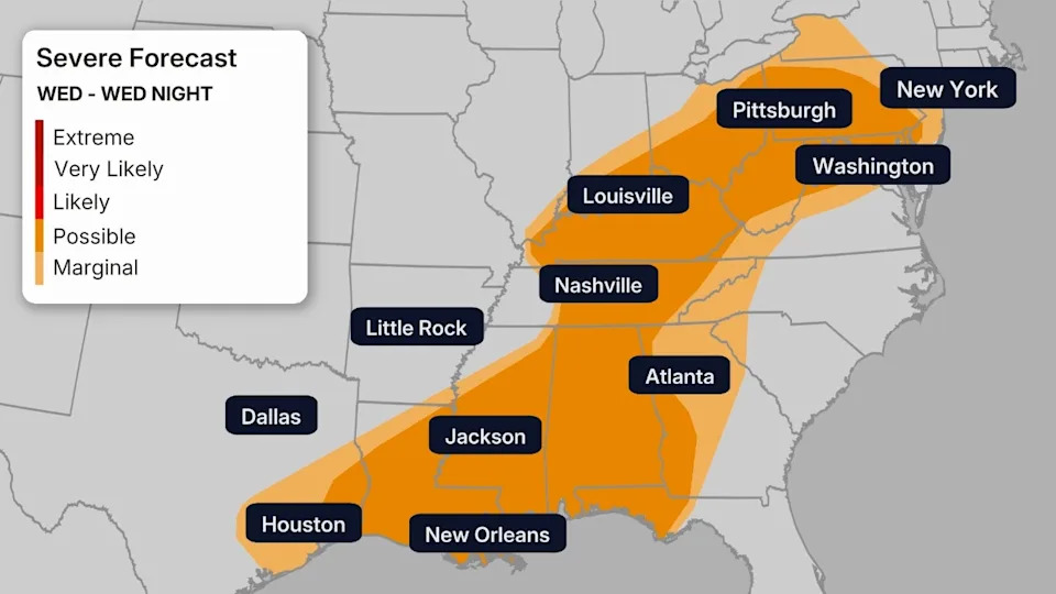
Thursday, only a few severe thunderstorms are possible near the Southeast coast and Florida before the cold front sweeps through.
Flood Threat
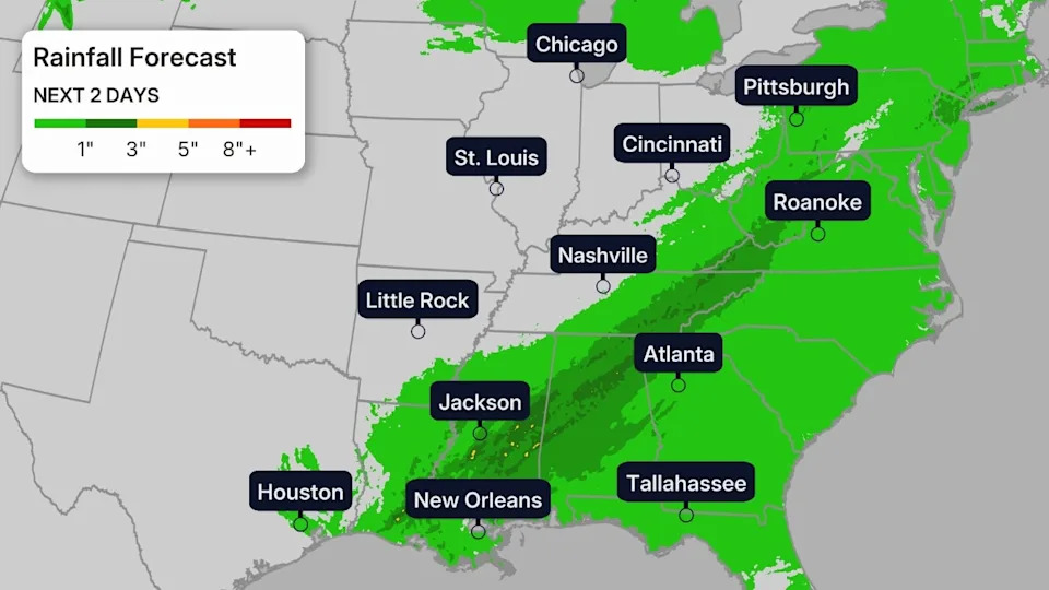
Along with the severe threat, these storms may also bring heavy rainfall. Some of these areas saw heavy rainfall from last week’s storms, so rain will be falling on already-soggy soil in some cases.
Another 1-3 inches of rainfall is possible, with higher totals expected across areas where slow-moving storms train over the same location for a few hours. Local flash flooding is possible.
Prepared, Not Scared
You can stay as safe as possible during severe thunderstorms by following these general tips:
– Have multiple ways of receiving official watches and warnings from the National Weather Service, including from your smartphone and from NOAA weather radio. Make sure your smartphone and NOAA weather radio are fully charged and notifications are turned on, in case a warning is issued while you’re sleeping.
– Before a storm threatens, determine where the best place to take shelter is when a warning is issued where you live. If you live in a manufactured home, you should consider where the nearest community storm shelter or nearby home is that you can get to quickly.
– When a warning is issued, take shelter immediately, including for severe thunderstorm and tornado warnings. Don’t waste precious time looking out a window. Some tornadoes are hidden by rain or may not be visible at night if lightning isn’t frequent enough.
(MORE: 14 Things You Should Know About Severe Weather)
What Happened Yesterday
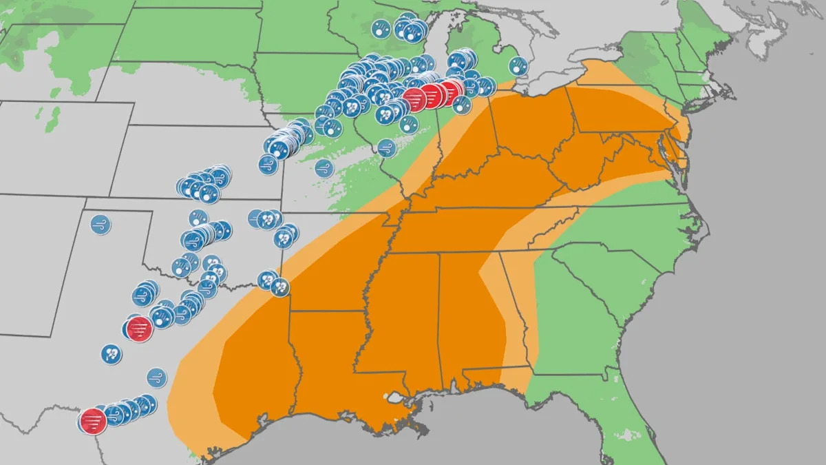
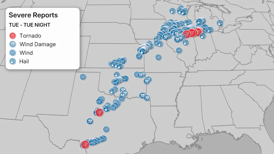
About 230 reports of severe weather were received by the National Weather Service Tuesday through early Wednesday morning, the most of any 24-hour period in the U.S. since July 28.
The most heavily damaged areas were from one supercell thunderstorm which tracked over 120 miles in almost 4.5 hours from northeast Illinois into northern Indiana. That supercell spawned destructive tornadoes in Kankakee, Illinois; Lake Village and Wheatfield, Indiana, according to the National Weather Service. Portions of this area have been surveyed and an EF1 tornado has been confirmed near Wheatfield, Indiana, with winds of around 110 mph.
(EXPERT ANALYSIS: The Setup For The Long Track Supercell)
This supercell also dumped giant hail from 5 to 6 inches in diameter in or near Buckingham, Campus and Kankakee, Illinois. This may have set a state hail record, something an ad hoc committee of meteorologists will examine at a later date.
A tornado emergency was issued for Knox, Indiana, last night. Survey teams will release information in the coming days.
A second supercell thunderstorm tracked into Chicagoland, dumping 3 to 5-inch diameter hail in the far southwest suburbs of Bolingbrook and Darien, then half-dollar size hail downtown at the Loop.
Elsewhere, hail up to baseball size pelted the western Oklahoma City metro area from a tornado-warned supercell thunderstorm. Several severe thunderstorms pelted the Kansas City metro with hail up to 2 inches in diameter.
At least two tornadoes touched down in western Texas, one just southeast of Abilene and the other just east of Laughlin Air Force Base near Del Rio.
There were also two EF1 tornadoes in southeastern Iowa near Donnellson in Lee County. One tornado had winds of 100 mph while the other had winds of 90 mph.
An EF1 tornado also moved through Moro and Midway, Illinois, early on March 11 with winds of 95 mph. There was one injury reported.
Flash flooding stranded vehicles in Grand Rapids and near Holland, Michigan.
(MORE: Latest News And Impacts)
Data: NOAA/NWS/SPC
First Appeared on
Source link


Leave feedback about this