
Meteorological spring arrival to meet with wintry storms in Midwest, Northeast
As meteorological spring begins on March 1, winter will make yet another comeback from the Midwest to the Northeast. Multiple storms bringing rounds of snow, ice and rain will impact about 120 million people through the middle of next week.
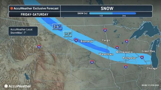
A swath of snow will extend from Montana to southern Michigan into Saturday. Milwaukee and Madison, Wisconsin, as well as Rochester, Minnesota, are forecast to pick up 1-3 inches from the weak system.
AccuWeather.com
Brief taste of spring precedes colder air, wintry storms
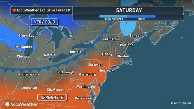
A large area of warm air will hang on for one more day in the Ohio Valley and briefly extend into the Northeast on Saturday.
AccuWeather.com
Combined with late-February sunshine, it may feel even warmer than the projected highs in the 40s, 50s and even 60s F in some areas. However, the brief taste of spring will not last.
Arctic air on the move
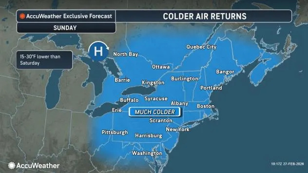
Arctic air is surging across Canada and is forecast to sweep southeastward over the weekend, reaching the Upper Midwest on Saturday and the Northeast on Sunday.
AccuWeather.com
How far south the Arctic front pushes will determine how far north snow and mixed precipitation extend with the next storm.
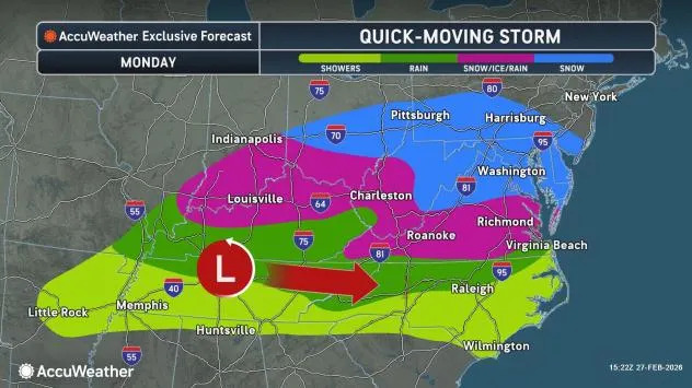
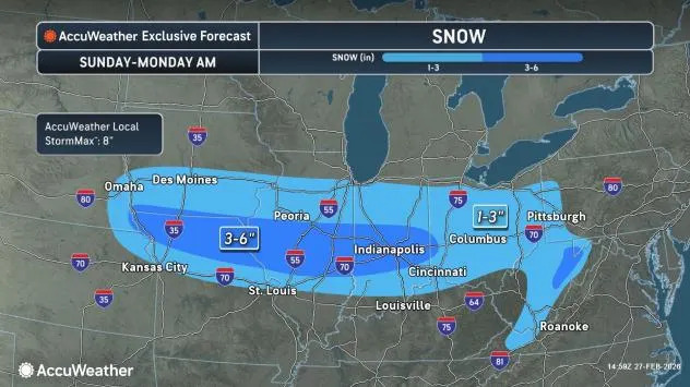
Snow, ice streak eastward from Sunday to Monday
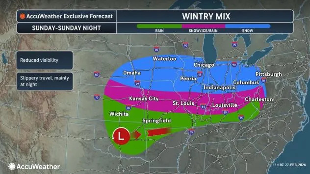
Snow, ice and rain will spread from the central Mississippi and Ohio valleys on Sunday to parts of the Atlantic Seaboard on Monday.
AccuWeather.com
The Arctic air will help create a larger zone of snow and ice.
The Sunday-to-Monday storm will have more moisture to work with than the systems that followed the Blizzard of 2026, making it more capable of producing 1-6 inches of snow.
AccuWeather.com
However, the storm’s weak nature is likely to prevent much heavier snow accumulations. Midwest cities most likely to get enough snow to shovel and plow include Springfield, Illinois; Indianapolis; and Dayton, Ohio.
Another small bubble of snow is likely for the mountains in West Virginia and perhaps western Maryland. Wet, slushy and slippery conditions are anticipated as far north as the Interstate 80 corridor, with wintry travel likely along much of Interstate 70 from Missouri to Pittsburgh from Sunday into Monday morning.
AccuWeather.com
In areas east of the mountains in Pennsylvania, Maryland, northern Virginia, Delaware and southern New Jersey, where snow or a wintry mix becomes intermittent from midday into Monday evening, precipitation may melt on treated roads. In much of this zone, accumulations of a coating to an inch are likely, mainly on non-paved surfaces.
Secondary roads and sidewalks may still be slippery, and motorists should expect wintry conditions for the Monday morning drive in the Appalachians and the Piedmont areas as well as in the Shenandoah Valley of Virginia.
AccuWeather.com
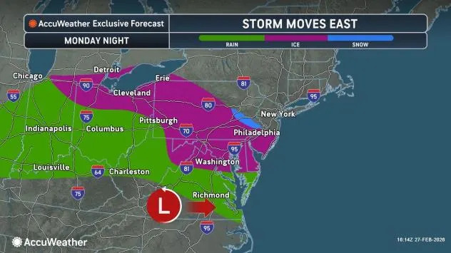
Storm from Tuesday to Wednesday to be larger and warmer
A larger storm will affect parts of the Midwest and the Northeast from Tuesday to Wednesday, overlapping with lingering snow, ice and rain from Monday’s system in parts of the Northeast.
This next storm will spread snow and a wintry mix farther north, including parts of the Great Lakes and the Northeast on Tuesday.
“A key to the storm from Tuesday to Wednesday will be the Arctic high-pressure area, which will be moving off the mid-Atlantic coast, rather than holding its ground,” AccuWeather Senior Meteorologist Matt Benz said. “Southerly breezes will allow a swift warmup so that snow and ice quickly transition to rain in most areas over the mid-Atlantic and New England from Tuesday to Wednesday.”
AccuWeather.com
Since there is still a significant amount of ice on some streams and rivers, the higher temperatures and rain will tend to break it up. Where the ice jams up, there is a risk of rapid rises in water levels above the jams and then below where the jams break. Some unprotected areas along flood-prone streams and rivers could be at risk.
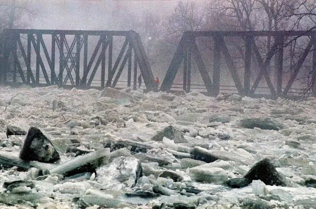
Ice jammed the Winooski River and caused it to flood downtown Montpelier, Vt., in March 1992. (AP Photo/Toby Talbot)
With a massive amount of snow still on the ground – including large piles in urban areas from Philadelphia to New York City, Boston and Providence, Rhode Island – urban flooding is likely from Tuesday to Wednesday as rain combines with melting snow. Clearing storm drains ahead of the storm may help reduce the risk of deep flooding in city streets.
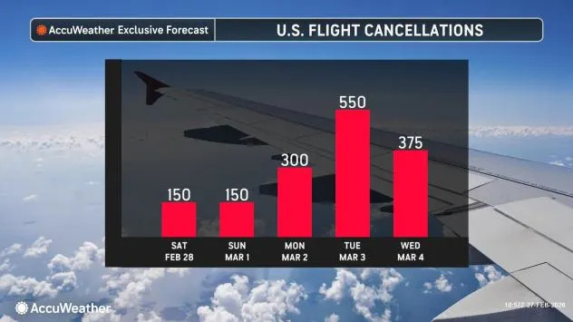
Another problem that may impact ground and air travel in parts of the Midwest and Northeast with the upcoming storms will be areas of fog. Anytime warmer, moist air flows over cold ground or snow cover, fog may form and could become locally dense.
Want next-level safety, ad-free? Unlock advanced, hyperlocal severe weather alerts when you subscribe to Premium+ on the AccuWeather app. AccuWeather Alerts™ are prompted by our expert meteorologists who monitor and analyze dangerous weather risks 24/7 to keep you and your family safer.
First Appeared on
Source link


Leave feedback about this